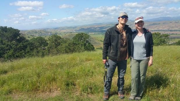
Meet Tanya Diamond and Ahiga Snyder, researchers who specialize in identifying, monitoring, and implementing connectivity designs for wildlife movement. What does that mean? They work with land trusts and conservation organizations like Protect Coyote Valley to track local wildlife and evaluate the best ways to co-exist with it.
Imagine a bobcat roaming to find food, water, or a mate. She crosses highway 101 and is hit by a car — killing her and endangering the driver. That’s exactly the type of accident that Tanya and Ahiga are dedicated to preventing. Coyote Valley is the only undeveloped connection between the Santa Cruz mountains and the Diablo range, so it’s a crucial habitat and passageway for many animals, including bobcats, pumas, foxes, coyotes, and badgers. Tanya and Ahiga’s goals are to identify prime corridors along roadways and work with local agencies to protect that land and enable animals to traverse it safely.
“We want our science to result in applied conservation.” — Tanya Diamond, Wildlife Ecologist-GIS Analyst
How it all began

Tanya launched her career 10 years ago when evaluating whether some land in Big Sur needed protection. Immediately after placing cameras along the roadway, she captured pictures of a female mountain lion crossing the road. The saying “a picture is worth a thousand words” certainly applies here. Although, Tanya’s pictures netted a $3.1 million grant to protect the property and its wild inhabitants. Hooked, Tanya began her own wildlife connectivity company and shortly hired Ahiga as her partner.
Ahiga grew up in the Sierra Nevada mountains tracking wildlife with his Navajo grandfather. He and Tanya hit it off immediately and launched a partnership that not only protects land and animals up and down central California, but is also resulting in their wedding, taking place amidst the redwoods in 2019.
A typical day for an atypical career

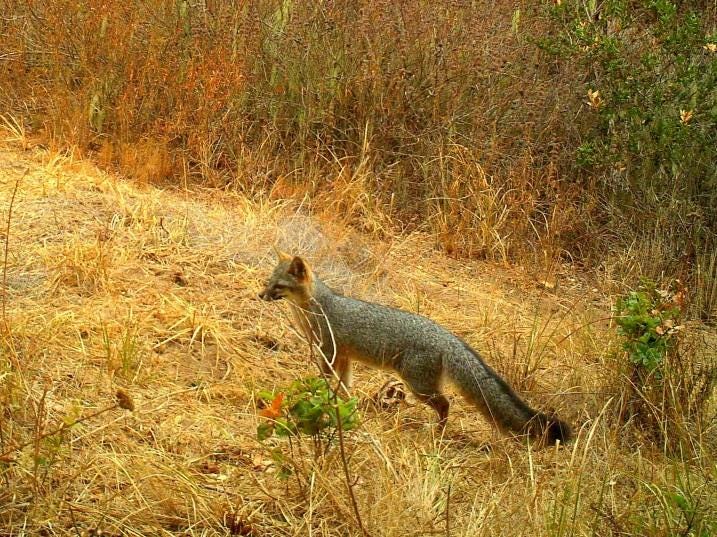
In Coyote Valley, Tanya and Ahiga focus on tracking bobcats because “they are great commuters.” On a typical morning, the couple travels through the valley, checking their cameras, looking for roadkill, and tracking the bobcats’ locations via radio collars. They enter and analyze the data, which is used to make informed decisions about what land to protect. “We need open space on each side of the road where animals cross,” says Tanya. “We don’t want them traipsing through someone’s backyard.”
“The goal is a healthy ecosystem,” adds Ahiga. “And that includes humans.”
The importance of connectivity
Tanya and Ahiga share that wildlife connectivity is a somewhat new concept. Instead of focusing on a single threatened species, it focuses on multiple species that co-exist within developed areas. In addition to being hit by cars and losing their food and habitats, animals in highly developed areas are threatened by a lack of genetic diversity.
“Canine distemper wiped out an entire kit fox population in Southern California,” says Ahiga. “Because the animals were so isolated by roads and development, they were not genetically diverse enough to resist the disease. And now, the kit fox is an endangered species. That’s a cautionary tale for us.”
Tanya adds, “Andrea Mackenzie from the Santa Clara Valley Open Space Authority calls Coyote Valley a ‘last-chance landscape.’ This truly is our last chance to protect it.”
And that’s exactly what Tanya and Ahiga will continue to do, even as they plan the upcoming “Navajo-80s dance party fusion wedding” of Tanya’s dreams.
Walk with them and find out more!
- Read more about Coyote Valley’s bobcat tracking program.
- Read more about POST’s property purchases in Coyote Valley, aimed at protecting the area.
- Sign up to receive our monthly newsletter, featuring other event information and Coyote Valley news, or volunteer to stand up and step out when we need our community’s support to spread the word about Coyote Valley.
[intense_hr accent_width=”30″ accent_height=”3″]
About Protect Coyote Valley
The Protect Coyote Valley campaign is led by the Committee for Green Foothills and supported by Greenbelt Alliance, Keep Coyote Creek Beautiful, Santa Clara Valley Audubon Society, Sierra Club Loma Prieta Chapter, and SAGE — Sustainable Agriculture Education. It aims to preserve Coyote Valley, San Jose as open space that offers flood-buffering wetlands, an essential wildlife habitat and migratory area, and active farmlands.